© Seapilot 2011
The manual may not in any aspect be copied without the prior authorization from Seapilot AB.
----------------------- Page 2-----------------------
1 REVISION ....................................................................................................... 3
2 INTRODUCTION ........................................................................................... 4
3 GLOSSARY..................................................................................................... 5
4 CONDITIONS ................................................................................................. 6
5 SUPPORT ........................................................................................................ 7
6 SEAPILOT....................................................................................................... 8
6.1 Functions .............................................................................................................. 8
6.2 Forthcoming functions ......................................................................................... 9
7 HOW TO USE SEAPILOT ............................................................................. 9
7.0 Display ............................................................................................................... 12
7.1 Control panel ...................................................................................................... 13
7.2 Info panel............................................................................................................ 20
7.3 Settings menu ..................................................................................................... 23
a) General ........................................................................................................... 24
b) Own ship ........................................................................................................ 25
c) AIS ................................................................................................................. 26
d) Chart............................................................................................................... 26
e) Instruments..................................................................................................... 26
f) Units ............................................................................................................... 27
g) Other............................................................................................................... 27
8 AIS ................................................................................................................. 28
8.1 How AIS works .................................................................................................. 28
8.2 AIS Classes ......................................................................................................... 29
8.3 Limitations with AIS .......................................................................................... 29
8.4 Seapilot AIS features .......................................................................................... 29
9 Electronic Bearing and Range Marker ........................................................... 33
10 Routes and Waypoints ................................................................................... 34
11 Mark ............................................................................................................... 41
12 Chart objects information............................................................................... 42
13 FAQ................................................................................................................ 43
14 NOTES ........................................................................................................... 43
----------------------- Page 3-----------------------
1 REVISION
Version Date Responsible Approved Changes
1.0PE 2011-06-30 Anders Bergström First draft
1.0E 2011-08-01 Anders Bergström Joakim Schedin First release
1.1E 2011-08-04 Anders Bergström Joakim Schedin New pictures
1.2E 2011-08-06 Anders Bergström Joakim Schedin New text on
marker, new
pictures and
correction of
language
1.3E 2011-08-08 Anders Bergström Joakim Schedin New procedure to
register product.
1.4E 2011-08-24 Anders Bergström Joakim Schedin Adding new
features like
waypoints and
routes. Release 2.32
1.5E 2012-02-18 Anders Bergström Mats Tegner Adding new
features like search
and head up.
Release 2.
----------------------- Page 4-----------------------
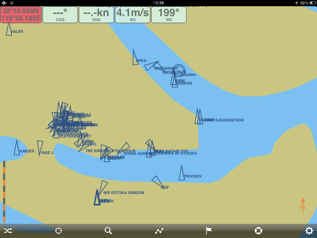
2 INTRODUCTION
Thank you for choosing Seapilot to deliver your new APP. Seapilot is a high quality
IPAD navigation solution based on technique used by professionals. Seapilot has built in
features to receive information from other ships, buoys, lighthouses, SAR helicopters,
Coastguard units, Pilot boats, Weather stations etc. that are equipped with Automatic
Identification System (AIS) transponders. It is today a requirement for all ships above
300 GT to carry AIS according to IMO, SOLAS regulation. This means that a large
quantity of ships and other types of navigational hazards or information providers will be
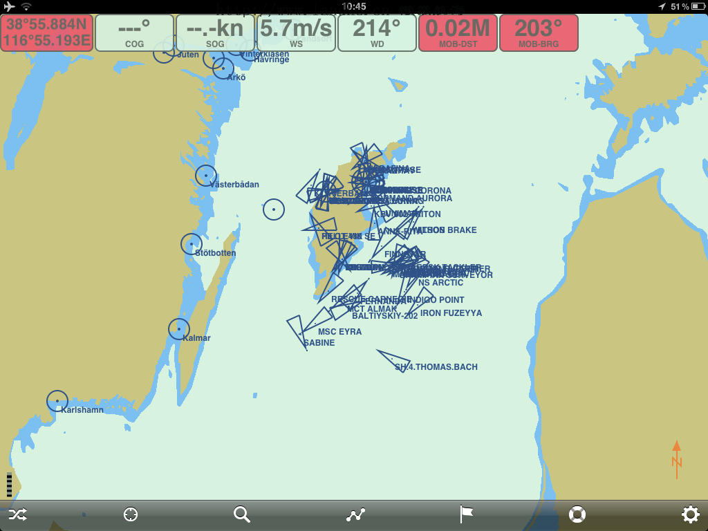
seen by your application and contribute to enhanced safety in your navigation.
Real traffic scenario in Stockholm City (Sweden)
It is of utmost importance that you read this manual before you start to install and use
your Seapilot app.
----------------------- Page 5-----------------------
3 GLOSSARY
To make the reading of the manual easier we like to start up with introducing the used
abbreviations and glossary:
AIS Automatic Identification System
DGPS Differential Global Positioning System
ETA Estimated Time of Arrival
ETE Estimated Time Elapsed
GPS Global Positioning System
GALILEO European equivalent to GPS
GNSS Global Navigation Satellite System
GT Gross Tonnage
IMO International Maritime Organization
MOB Man Over Board
NM Nautical Mile = 1852 m
RX Receive/Receiver
SMA Swedish Maritime Administration
SOLAS Safety Of Life At Sea
SOTDMA/STDMA Self Organized Time Division Multiple Access.
VHF Very High Frequency
VTS Vessel Traffic Services (Like ATC but for ships)
WS Weather Station
----------------------- Page 6-----------------------
4 CONDITIONS
Before you start using the product from Seapilot it is important that you read and fully
understand the operation manual and its instructions. You should only proceed with the
use if you are confident that you will be able to do so.
Seapilot AB cannot be held liable for any injury or damage caused by, during or because
of the operation of Seapilot. Seapilot is used at your own risk and it shall be remembered
that AIS data depends on the full co-operation of other users and systems.
Seapilot is a navigation aid and works in co-operation with other similar systems like e.g.
radar, optical lookout etc. Seapilot should be inspected from time to time and checked on
its operational quality frequently by the user. Remember that navigation and life at sea
always requires proper seamanship and that the Seapilot is not a replacement for such
qualities.
NOT ALL VESSELS CARRY AIS. IT IS THEREFORE IMPORTANT TO KEEP
PROPER LOOKOUT AT ALL TIMES AND TO USE ALL AVAILABLE MEANS
TO AVOID COLLISIONS AND ACCIDENTS.
Proper seamanship and common sense is applicable when using Seapilot and the product
shall only be seen as a navigational aid. Seapilot keeps the right to change the
specification of the product without prior notice.
IF YOU ARE NOT ABLE TO ACCEPT THE TERMS ABOVE, PLEASE DELETE
THE SEAPILOT APPLICATION BEFORE USED.
----------------------- Page 7-----------------------
5 SUPPORT
If you need support, please contact as follows:
SEAPILOT:
Email:
support@seapilot.se.
To be able to get access to your Seapilot support you need first to register your purchase
of Seapilot at
http://www.trueheading.se/sv/registrera-din-produkt.
----------------------- Page 8-----------------------
6 SEAPILOT
Seapilot is a unique navigation system for iPad based on merchant shipping standards for
electronic navigation, with S-57 chart data from the Swedish Maritime Administration,
and for the first time ever integrated in a navigation app: AIS tracking and AIS weather in
real time. Seapilot unites utility with safety and can do more than traditional navigation
equipment, at a fraction of the cost!
Seapilot is a navigation aid and is intended to help your navigation to become safer and
more accurate. Its data depends on technical inputs from various other systems like GPS,
AIS, Mobile Cellphone Base station networks and finally on chart data provided by
hydrographic offices and maritime administrations. All these data can be subject to
various errors depending on the source from where it is provided and what quality that
source or sensor has for the time of operation. Please also note that iPad ´s can only
position your boat if you have an iPad with 3G/GSM functionality at present.
Seapilot uses the latest technology to provide a navigation system based on standards
used by the professional mariners. With Seapilot you obtain:
 A professional navigation system based on merchant shipping standards for
ECDIS (Electronic Chart Display and Information System).
 S-57 chart data from the Swedish Maritime Administration.
 AIS tracking in real time (Automatic Identification System) displaying all ships
equipped with an AIS transponder.
 Weather in real time via AIS from over 60 weather stations in Sweden – showing
average wind speed, wind direction, air pressure, temperature etc. Automatically
displays information for the weather station closest to the screen’s position.
 A system developed in a unique collaboration between Stockholmradio and True
Heading, market leaders within marine navigation and communication at sea, with
cutting-edge expertise within AIS and VHF.
6.1 Functions
Δ Positioning via GPS and mobile networks
Δ Visualisation of S-57 chart data from the Swedish Maritime Administration
Δ Based on merchant shipping standards for ECDIS (Electronic Chart Display and
Information System)
Δ AIS data from the Swedish Maritime Administration via the internet (3G or WLAN)
Δ Course and speed vectors on AIS targets
Δ AIS weather data in real time from over 60 weather stations
Δ Visible presentation of individual position, course and speed over ground
Δ Autonomous navigation as the sea chart is downloaded to your iPad-unit on installation
Δ Rapid chart management
Δ Easy return to own position
Δ Option of tracking your own boat on the chart
Δ Adjustable own speed- and course vector
Δ Man Over Board function
----------------------- Page 9-----------------------
Δ Routes/Waypoints
Δ Display setting for Day, Dawn/Dusk and Night
Δ North up chart orientation and True Motion
Δ Plotting/Marking objects
Δ Electronic Bearing and Range Marker from own ship
Δ High definition (HD)
Δ Search function (NEW)
Δ Adjustable chart orientation (Head Up) (NEW)
Δ Own track (NEW)
Δ Setting of safety contour (NEW)
6.2 Forthcoming functions
• Expanded functionality for AIS data • Graphic race result presentation, for example
sailing races (incl. SRS-handicap) • Social functions via AIS
• Aids to navigation AIS capability • GRIB-weather presentation • Connection to on
board sensors. • Anchor watch using AIS • Export of Waypoint data
7 HOW TO USE SEAPILOT
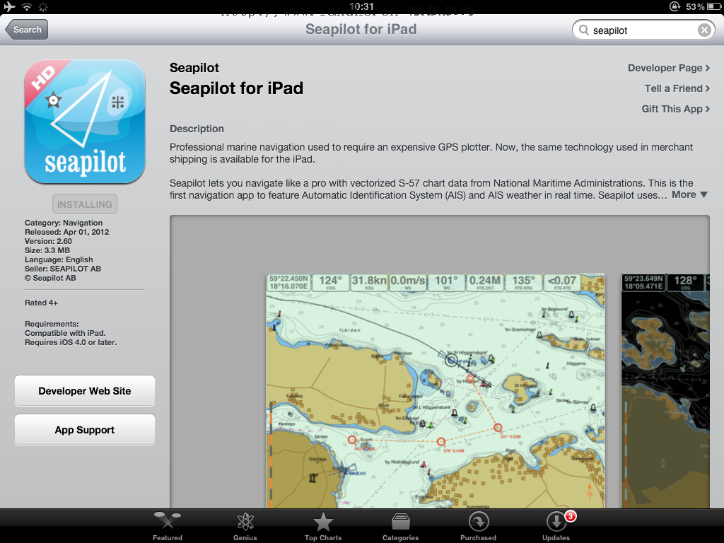
When starting up Seapilot for the first time you will from version 2.60 be asked to
download you charts separately from the acutall app. This is a new feature to make it
possible to handle further chart areas like extension to eg. Denmark, Finland and Norway
that will be available during spring 2012. Also the special charts from Hydrographica for
Sweden will be available from version 2.60. Please refer to the chart areas from
Hydrographicas webpage
www.hydrographica.se. A chart cell in Seapilot is equivalent to
a paperchart sold by Hydrographica. Charts can always be downloaded at any time and is
treated as a renewable subscription meaning that your chart will be updated as table 1
below describes. Appstore will automatically reniew your subscription when it expires
after one year unless you actively stop that transaction. If the transaction is stopped your
charts will remain useable but not longer updated and when starting to navigate you will
be asked if you like to update your charts. Users having bought Seapilot before version
2.60 will automatically receive a free year of chart updates from the date downloading
the new version (But not later then April 30th).
----------------------- Page 10-----------------------
Either Subcriptions can be selected that is used to subscribe to the cart annually with cost
as below (2012). Special charts are for download of charts like e.g. Hydrographica that
are a one time cost when a specific cell is downloaded. If Special charts is selected a new
meny will occur with the available charts for that segment.
----------------------- Page 11-----------------------
Restore purches is to be used of data has been lost from the device its used on. You will
be asked for your Appstore/Itunes password and restore of previously bought charts will
start automatically.
Country (Chart) Updates per year Update period Price/Year
Sweden 2 April-August 289 SEK
Finland 2 April-August TBD
Denmark 1 April-June 899 SEK
Norway 2 April-September TBD
Hydrographica No updates* - 85 SEK/Cell
*Few updates for Hydrographicas charts are made and therefore a subscription service is
not required.
Table 1
----------------------- Page 12-----------------------
7.0 Display
The view below is presented without any information at all in the chart. As a user you
have the possibility to select what data you need to present and display in your chart. This
provides you with the possibility to have the “cleanest” possible view available for
navigation. To zoom in and out is done by using two fingers moving away from each
other to zoom in and moving towards each other to zoom in.
Own ship is presented as two circles with a heading and speed vector pointing in the
direction of the course over ground acquired from the GPS as well as a speed vector
presenting the position of own ship within 10 s, 30 s or 60 s depending on preferred value
in settings menu. Please also note that iPad ´s can only position your boat if you have a
iPad with 3G/GSM functionality at present. Please also be aware that Location Services
----------------------- Page 13-----------------------
under Settings in the main iPad settings meny has to be activated for Seapilot Sweden to
allow correct positioning of own ship in Seapilot.
7.1 Control panel
The field at the bottom of the screen is called the control panel. From the control panel
you can control the main functions of the Seapilot navigation system.
The CONTROL PANEL function switches the control panel on and off.
The OWN SHIP SYMBOL gives you three possibilities to control how to
position your own ship on in the chart.
Follow means that you will return to own ships position independent of where you are
located in the chart. You are free to zoom out and in as well as to off center at any time.
Follow Lock means that you will return to own ships position at once when selected and
remain on this position until Follow Off is selected. Zoom in and out is still possible but
not off center functionality. The Follow Lock functionality has a box created around own
boat that will allow own position to return to the center if the “box” moves outside the
view. The “box” can be moved to any position on the screen by panning own position to
another location on the screen. This will give possibility to obtain maximum visible chart
area infront of own boat when navigating e.g. in high speed. When changing course the
optimiced look ahead view is obtained by a new manual pan of own ship to any position
on the screen.
----------------------- Page 14-----------------------
The SEARCH symbol in the control panel gives you three possibilities to
search for data in the chart or on AIS targets. By selecting Ship you will
be able to search for AIS ships from the database of AIS data. Also not
currently transmitting ships will be shown at last known position. By
selecting Chart you will be able to search from the S-57 data base of
names included in your charts.
----------------------- Page 15-----------------------
When the SEARCH symbol is selected a field will occur where you have to input the
name of the ship or the destination or object you are searching for. When SEARCH
(SÖK) is selected on the keyboard a list with possible matches are presented in the table
below the name input field and when selected the chart will center to the ship or
destination searched for.
----------------------- Page 16-----------------------
A ship/boat that is not currently visible in the AIS system can still be located at its last
known position using the SEARCH function. The procedure is the same but the currently
not available target will be presented with a cross over it.
----------------------- Page 17-----------------------
The ROUTE and WAYPOINT symbol gives possibility to create routes in
the chart by adding a number of waypoints. The procedure to add a route
is as follows is decribed in chapter 10.
The MARK flag is used to administrate the markers that can be placed
into the chart by holding your finger on to the display until a cursor
appears. When the cursor is placed on a position you will be asked if you
like to add a mark. When the control panel icon is selected without any
active marks only the list function will occur.
----------------------- Page 18-----------------------
The MARK key will if selected show two possibilities either to Deactivate selected
MARK or to List all MARK’s currently placed in the chart. A deactivated MARK will
occur in the chart without the outer circle as the activated MARK will have two circles
around the MARK symbol.
When a listed MARK is selected Seapilot will automatically zoom into the area where the
selected MARK is positioned. See also chapter 11.
MAN OVER BOARD is used to be able to locate a person falling
overboard by fixing the position by pushing this button when a person
falls overboard.
A red-marked position will occur and MOB-BRG (Man Over Board – Bearing) as well as
a MOB-BRG (Man Over Board Distance) giving the course to steer and the distance from
own position to the person in distress. Symbol will also occur in the chart at the position
where the MOB function was activated.
----------------------- Page 19-----------------------
To deactivate the MOB function, press the MOB button again and you will be asked to
delete the MOB target.
The control panel also exists of a Settings icon. In settings all functionality
is controlled for the Seapilot app se chapter 7.3.
----------------------- Page 20-----------------------
7.2 Info panel
In the top of the chart a Info panel is presented at selection if wanted. The Info panel is
controlled from settings and can include the following panels.
----------------------- Page 21-----------------------
Own ship position Speed over ground Average wind direction at closest WS
Own ship course over ground Average wind speed at closest WS
Additionally also in the Info panel the bearing and distance to a MARK, CURSOR and a MOB
symbol can occur.
If no AIS data is provided from a network a frame in the Info panel will occur telling no
AIS data is available.
Active MARK symbol
Not active MARK symbol
MOB symbol
----------------------- Page 22-----------------------
Waypoint symbol giving bearing and distance to next waypoint.
Wapoints are numbered from zero and up if no specific name is
given to the waypoint.
An active waypoint is presented by two circles and still with bearing
and distance to the next. By passing the active waypoint the next
waypoint in the route is automatically selected.
For the active waypoint and route an info panel will also occur that shows range, bearing
and cross track distance to next active waypoint.
----------------------- Page 23-----------------------
7.3 Settings menu
The Settings menus consist of several possibilities to select how you like your app to
present information in your preferred way. The following settings are available:
----------------------- Page 24-----------------------
a) General
Color sets the navigation display into Day (daylight) backlight, Dusk (dawn or dusk) and
Night backlight functionality.
----------------------- Page 25-----------------------
DUSK NIGHT
Use GPS selects if you should use the GPS for navigation or not. If OFF it will not give
position or COG or SOG to the application. The position is based not only on satellite
data but also on the position of the IPAD in relation to a mobile base station. A GSM or
3G network can be used as well to position own ship (the IPAD) you are e.g. inside a
building or with poor GPS coverage inside a boat. The accuracy of such position is
however much less then a GPS position. Good margins should always be kept in the
navigation to avoid the error of own position that can be anything between 5-400 meters
depending on how position fix is acquired. Seapilot will warn you if your accuracy is
below 20 m when the own position field will become red. Please also note that iPad ´s
can only position your boat if you have a iPad with 3G/GSM functionality at
present. Please also be aware that Location Services under Settings in the main iPad
settings meny has to be activated for Seapilot Sweden to allow correct positioning of own
ship in Seapilot. The Charts meny is used to manage your charts and a separate menu
will occur when selected. Hide status bar is used to hide the to status bar normally
presented on an iPad or iPhone
b) Own ship
Speed vector time marks will select how own ship speed vector is presented. 10 s, 30 s or 60 s
are selectable.
Show past track will add a track after your own boat.
Clearpast track will delete the track.
Headup will put your screen in head up presentation instead of north up if ON.
----------------------- Page 26-----------------------
c) AIS
Download AIS targets and weather information gives your application the unique feature to
have AIS data presented in your chart when navigating. The presentation of AIS requires a
connection to a local area network or to a 3G/GSM network to access the AIS data that is
provided in Sweden from the Maritime Administration. If the function is selected to be OFF
no AIS targets are displayed.
Show target names will add name to the AIS target if that particular boat has name
programmed in its AIS if ON.
Show AIS target speed vectors will add a speed vector to all AIS targets with he same time
marks as for own ship speed vector if ON.
Show weather station names will add name to the AIS weather stations around the cost if
available. Some weatherstation can be without name if they eg are newly added or originally
outside Sweden at present in ON.
d) Chart
Safety contour will make it possible to select a safety contour from 2-15 m depending on
what S-57 data is available in the chart. Note that eg. in charts from Hydrographica only a 2
and a 3 m contour is available.
Show soundings will give depth figures in meters in the chart if ON.
Show underwater cables will present cables in chart if ON
Show lights will present light sectors of lighthouses and buoys if ON
All the three features above are implemented to de-clutter the chart picture if desired by the
user.
e) Instruments
The Instrument field selects how presentation will be done in the Info panel
Show position will activate or deactivate own position in Latitude and Longitude.
Show course over ground (COG) ON and OFF in the Info panel
Show speed over ground (SOG) ON and OFF in the Info panel
Show wind speed (WS) ON and OFF will present from the closest or selected AIS weather
station the wind speed.
----------------------- Page 27-----------------------
Show wind direction (WD) ON and OFF will present from the closest or selected AIS
weather station the wind direction.
f) Units
Position format can be selected to present the latitude and longitude position as
N59.0000 or N59˚00,00
g) Other
Help & Manual will direct you to Seapilots webpage where further useful information
can be found.
----------------------- Page 28-----------------------
8 AIS
AIS (Automatic Identification System) is the name of a system that makes it possible for
ships to identify other ships and to monitor ship movements. The reason for
implementing the AIS system is for the mariner to obtain more information about ships in
the vicinity than what radar is able to provide. AIS gives e.g. information about a ships
identity (name, call sign, IMO number and MMSI), size this even for ships behind Island
or bends that radar cannot detect.
AIS is used to enhance safety for life at sea, improve safety and efficiency in navigation
and protect the marine environment. AIS-information transmitted from a ship contains of
three (3) different main types:
- Static data that was programmed into the AIS equipment at installation and it only
needs to be changed if the ship changes its name, flag or undergoes a major refit where
size or ship type is changed;
-Dynamic data contains information that automatically is updated from ship sensors like
the heading from the Gyro, Position and speed from GNSS equipment. Also navigational
status belongs to the group of dynamic data but is updated manually by the crew; and
-Voyage related data that manually is updated by the crew along the voyage.
8.1 How AIS works
The Automatic Identification System (AIS) is a location and vessel information reporting
system. It allows vessels equipped with AIS to automatically and dynamically share and
regularly update their position, speed, course and other information such as vessel
identity with similarly equipped craft. Position is derived from a Global Navigation
Satellite System (GNSS) network and communication between vessels is by Very High
Frequency (VHF) digital transmissions. A sophisticated and automatic method of time
sharing the radio channel is used to ensure that even where a large number of vessels are
in one location blocking of individual transmissions is minimised, any degradation of the
expected position reporting interval is indicated to the user and even if the unit suffers
extreme channel overload conditions it will always recover to normal operation.
----------------------- Page 29-----------------------
8.2 AIS Classes
There are two classes of AIS unit fitted to vessels, Class A and Class B. In addition AIS
base stations may be employed by the Coastguard, port authorities and other authorised
bodies. AIS units acting as aids to navigation (A to N) can also be fitted to fixed and
floating navigation markers such as channel markers and buoys.
Class A units are a mandatory fit under the safety of life at sea (SOLAS) convention to
vessels above 300 gross tons or which carry more than 11 passengers in International
waters. Many other commercial vessels and some leisure craft also fit Class A units.
Class B units are currently not a mandatory fit but authorities in several parts of the world
are considering this. Class B units are designed for fitting in vessels which do not fall into
the mandatory Class A fit category.
8.3 Limitations with AIS
You should always be aware that all ship others ships and in particular pleasurecrafts,
fishing boats, warships and some coastal stations and VTS centers not will be equipped
with AIS. Ships that have been mandated to carry AIS can also under certain conditions
turn of there AIS equipment at the master’s disgrace. Therefore it is important to be
aware that the information that AIS provides might not be the full and complete picture
of the situation around your ship.
Users of AIS must also be aware that transmission of false data can occur and that this
will be hazardous not only to your own ship but to other as well. The user is responsible
for all data that is entered into the system and for information provided by external
sensors. The accuracy of received AIS data is only as good as the information transmitted
from the source of information.
You should always be aware that wrong configured or calibrated ship sensors (positions-,
speed- or heading sensors) could lead to that wrong information will be transmitted.
Dangerous situations can occur if faulty information is shown on another ship.
8.4 Seapilot AIS features
Seapilot can as the first application provide AIS data from a competent authorities AIS
network system. The Swedish AIS system was one of the first AIS networks in the world
and has today a very good coverage along the Swedish coast with redunt basestations
providing high accessesibility.
Further the AIS network provides over 60 weatherstations that provide realtime
weatherdata from points along the coast of strategic importance. Seapilot can present all
these 60 stations at the same time and also 100 AIS target within the center of your view.
AIS target names will be displayed if that particular boat has its AIS programmed and
transmitting.
----------------------- Page 30-----------------------
The weather station is presented as a circle and when selected an open square will be
oriented around the circle. By tapping on the circle all data from that particular weather
station will appear. In settings you can select if you like names also to be presented on
each weather station.
----------------------- Page 31-----------------------
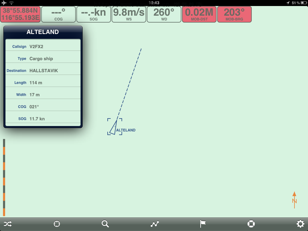
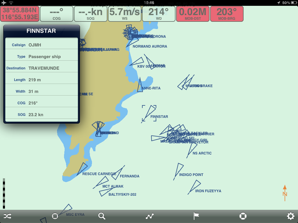
The same process is applicable to present data from an AIS Target. Tap on the AIS
symbol of the ship that is presented as a triangle showing on its top the actual heading of
the ship and if allowed also the name of the ship on the side of the triangle (if selected for
presentation as well)
To return to normal view just tap on the chart again.
----------------------- Page 32-----------------------
If the chart is zoomed in an AIS target will be shown at real size in the chart as shown
below.
----------------------- Page 33-----------------------
9 Electronic Bearing and Range Marker
Seapilot also has a electronic bearing and range marker that fast and easy can be used to
measure range and bearing to an object from own position. Just hold your finger on the
display close to the object you want to measure bearing and range to, a circle will appear
that can be moved around as long as you keep your finger on the screen. Bearing and
range will occure from own ship to the pointing cursor in the Info panel
Bearing & Range
Pointing cursor
----------------------- Page 34-----------------------
10 Routes and Waypoints
The ROUTE and WAYPOINT symbol gives possibility to create routes in the chart by
adding a number of waypoints. The procedure to add a route is as follows:
1. Tab on the ROUTE and WAPOINT symbon and a control function will occure
allowing creating a New Route. Select the New Route and then you can start to
add you first waypoint in the chart by putting your finger in the chart at the
position you like to place your waypoint.Keep the finger on the screen to be able
to move around and correctly place your waypoint at desired location.
2. When your waypoint is correctly positioned you should release your finger from
the screen and the next waypoint can be added in the same way.
----------------------- Page 35-----------------------
3. To Activate a route click again on the ROUTE and WAYPOINT icon and a new
control field will occur. Select the Activate field and your route will automatically
start to navigate against the closest waypoint in the selected route. Bearing and
distance and cross track will occur in the info panel. When the route is activated
the waypint symbol will get two circles instead of one and the info panel will
occur. By passing an active waypoint next waypoint will automatically be
selected.
----------------------- Page 36-----------------------
4. If the Info control function is selected Seapilot will show a field giving
information about the name of the route. The name can be changed by clicking on
the name field. Also the total distance of the route and distance to go from current
position as well as ETA and ETE. The route can be saved or deleted under this
control function as well.
----------------------- Page 37-----------------------
5. The Edit control function allows you to edit a specific waypoint. Select the Edit
key and then tab on the waypoint you like to edit. At present only name can be
edited on a waypoint. Your changes on the specific waypoint can be saved or a
waypoint can also be deleted from this control function. If you like to add a
waypoint between to exisiting once you just tab on the line between the waypoints
and a new waypoint will occur that can be freely placed as desired. If you like to
move an exisiting waypoint you need to put you finger on the waypoint you like
to move and place it at the new desired position.
6. When you have finished adding a new route or editing an exisiting one you need
to tell the system that you are done doing so by selecting the route and waypoint
control panel function again and selecting Done. At this control function its also
possible to choice in what direction you like to navigate your route. An entire
----------------------- Page 38-----------------------
route can be reversed meaning it can be navigated from both directions by choice
if Reverse is selected.
7. Select the Deactivate control function when finished navigation a route. An active
route can also be told to Reverse under this control function. Also the next or
previous waypoint can be selected manually under this control function by
selecting Next Wpt or Prev Wpt. When a route has been deactivated it can either
be re activated or closed by selecting Activate or Close in the control panel
function meny for routes.
----------------------- Page 39-----------------------
8. Finally a number of routes can be saved in your Seapilot app if properly saved
before. By selecting List in the control panel function meny for routes and
waypoints you will have a list of your saved routes presented.
----------------------- Page 40-----------------------
9. Select the route you like to operate and Seapilot will automatically center into the
start point of the selected route. At this stage all previously described functions
for handling your routes and waypoints can be applied to the selected route.
10. Do not forget that a route needs to be saved before you exit it and that to be able
to edit an exisiting route you need to select the Edit control function. Routes are
saved under the Info control function and specific waypoints under the Edit
function.
----------------------- Page 41-----------------------
11 Mark
In the same way as a pointing marker is applied also a marker can be placed in the chart.
A marker can also be given a specific name by entering desired name into the Name field
when the Add Mark field pops up.
The MARK field is undisplayed by tabbing anywhere in the chart. A MARK is deleted
or renamed by tabbing once on the marker.
----------------------- Page 42-----------------------
12 Chart objects information
Certain chart objects provides information that can be critical for navigation. Such
information are for example speed limits and clearance under bridges. Seapilot provides
by a simple tab on the object the necessary information required for safe navigation.
Speed limitations into Stockholm harbor 10 knots.
----------------------- Page 43-----------------------
Bridge clearance 5 meters
13 FAQ
To be provided
14 NOTES
 Manual Seapilot v1.5E.pdf (4.76 MB)
  |隐私政策|注册协议|注册协议|Landho 看海-懒猴航海-电子海图
( 津ICP备19004518号-1 )
|隐私政策|注册协议|注册协议|Landho 看海-懒猴航海-电子海图
( 津ICP备19004518号-1 )
 Seapilot 2011 操作手册: IMG_0106.PNG